Search on Scafell Pike / Broad
GPS Incorrect Setting
17th May 2006
6/20:17/5/06 ( 5.00 p.m. ) - Wednesday
A party of three staying in Eskdale drove to Borrowdale in order to walk up Scafell Pike. Initial callout information suggested they were lost on Scafell Pike. Incorrect GPS information revised this, suggesting they were near the plateau on Ill Crag. Actual location was near Broad Crag.
First call was at 4.30 p.m. where advice was given to get them from where they
were onto the nearest path however they struggled to follow the given
instructions. Full callout was at 5.00 p.m. The forecast was for
deteriorating conditions, heavy rain and strong winds, this was accurate. They
did not reach the summit of Scafell Pike and were unable to navigate of the
plateau despite having a GPS and map. It transpired that the GPS was on the
default setting, this gives an error of 400~ meters. They were found on
the north side of Broad Crag at 8.20 p.m. ( a lucky find given the weather and
information) fed and watered as they had not taken food on the hill. They
were walked off to Wasdale and transported back to Eskdale.
Incident closed at 00.00 hours with12 team members involved including around 12
attending at the Base as back up if the incident demanded more numbers on the
fell.
Note - GPS' should be set up to the 'British Grid' system and
'Ordnance Survey GB' datum so that they give
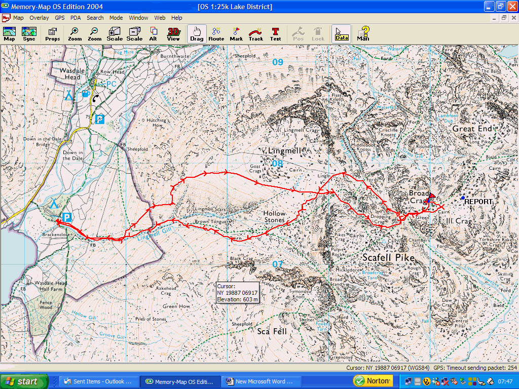
readouts consistent with the OS maps. The following track shows the route of the
rescuer, location of missing persons and route back down
The red line shows the rescue groups track up the nose of Lingmell, across to Lingmell Col and across the northern crags of Scafell Pike before traversing across to Broad Crag Col and up onto the next plateau. The red flag shows the position of the lost walkers. The marker which says REPORT is where the GPS grid reference had positioned them.
It is interesting to note that the search group made a slight deviation from the nose of Lingmell Col. This is because of the severe weather conditions and it was difficult for them to stay on their feet. They decided to make their way across to Brown tongue but due to the potential loss of height, made a further decision to head back up and climb the nose on the leeward side.
You can see from the above trail that the missing group, due to their GPS being incorrectly calibrated, gave their location as being on the plateau of Ill Crag when they were in fact on Broad Crag, 400 metres adrift. An error such as this could have disastrous consequences on the fell. This is a new phenomena for the team and we are currently exploring the best way of dealing with it.
Do we ask lost persons to tell us what settings their GPS are on?
Do we recalibrate their GPS over the phone?
Do we make our own correction at the base before we set off?
The consensus would be to ensure we get a good description of the territory so that a decision can be made as to whether the location given matches what is on the ground. Local knowledge plays an important part of this decision making.
We will keep you posted